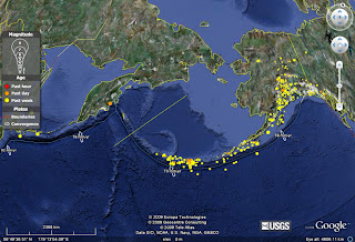
USGS provides a KMZ file with a very friendly and attractive interface for Google Earth. It loads the major earthquakes in our planet for the last 7 days, classified by time (Last hour, Last day, Last week), and by magnitude (from 1 to 8). If you click on each individual earthquake, you will open a box with its basic information and the url link for opening in your browser the complete information about it.
You can load this file in your Google Earth from the dedicated USGS website forseismology:
http://earthquake.usgs.gov/
It is on the left, "Google Earth KML". Anyway, the direct link to the file is:
http://earthquake.usgs.gov/eqcenter/catalogs/eqs7day-age.kmz
The interface also loads plate boundaries and convergence rates, measured in mm/year. I haven't found the source of the rates, but let's accept that if the data comes from USGS, should be fine. The plate boundaries included in the KMZ file are:
- Subduction zone.
- Oceanic transform fault.
- Oceanic spreading rift.
- Oceanic convergent boundary.
- Continental transform fault.
- Continental rift boundary.
- Continental convergent boundary.
 Of course, don't expect a very precise location for the plate boundaries! It is just an indication of the global tectonics of each area, in order to put the earthquakes in a correct geodynamic context.
Personally I find this KML file very useful, not only for the very up-to-the-date information given, but also for the boundaries, the rates... Useful thing when we have to prepare a simple figure in Corel or Freehand for a report.
No comments:
Post a Comment