What time is it??

Friday, November 27, 2009

World's Biggest Tsunami

The largest recorded tsunami was a wave 1720 feet tall in Lituya Bay, Alaska

On the night of July 9, 1958 an earthquake along the Fairweather Fault in the Alaska Panhandle loosened about 40 million cubic yards (30.6 million cubic meters) of rock high above the northeastern shore of Lituya Bay. This mass of rock plunged from an altitude of approximately 3000 feet (914 meters) down into the waters of Gilbert Inlet (see map below). The impact generated a local tsunami that crashed against the southwest shoreline of Gilbert Inlet. The wave hit with such power that it swept completely over the spur of land that separates Gilbert Inlet from the main body of Lituya Bay. The wave then contiuned down the entire length of Lituya Bay, over La Chaussee Spit and into the Gulf of Alaska. The force of the wave removed all trees and vegetation from elevations as high as 1720 feet (524 meters) above sea level. Millions of trees were uprooted and swept away by the wave. This is the highest wave that has ever been known.


Detail Map: Lituya Bay, Alaska

Lituya Bay Map
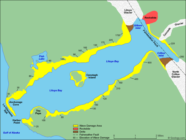
Lituya Bay is an ice-scoured tidal inlet on the northeast shore of the Gulf of Alaska. It is about seven miles long (11.3 kilometers) and up to two miles wide (3.2 kilometers). It has a maximum depth of about 720 feet (219 meters) but a sill of only 32 feet (9.7 meters) in depth separates it from the Gulf of Alaska between La Chaussee Spit and Harbor Point.

The Fairweather Fault trends across the northeast end of the Bay and is responsible for the T-shape of the bay. Glacial scour has exploited the weak zone along the fault to produce a long linear trough known as the Fairweather Trench. The Lituya Glacier and North Crillon Glacier have scoured portions of the Fairweather Trench in the area of Lituya Bay. Gilbert Inlet and Crillon Inlet occupy the Fairweather Trench on the northeast end of Lituya Bay.

The rock fall of July 9, 1958 occurred on steep cliffs above the northeast shore of Gilbert Inlet. It is marked on the map above in red. The rocks fell from an elevation of about 3000 feet (914 meters). The impact of 40 million cubic yards (30.6 million cubic meters) of rock hitting the water produced a local tsunami that swept the entire length of the Lituya Bay and over the La Chaussee Spit. This wave stripped all vegetation and soil from along the edges of the bay. This damaged area is shown in yellow on the map above. The numbers are elevations (in feet) of the upper edge of the wave damage area and represent the approximate elevation of the wave as it traveled through the bay. Map redrawn from data included in United States Geological Survey Professional Paper 354-C.

Monday, November 23, 2009

How Fast Did the Andes Mountain Range Rise?

Introduction: Andes Mountain Range


Trailing like a serpent's spine along the western coast of South America, the Andes are the world's longest continental mountain range and the highest range outside Asia, with an average elevation of 13,000 feet.

The question of how quickly the mountains attained such heights has been a contentious one in geological circles, with some researchers claiming the central Andes rose abruptly to nearly their current height and others maintaining the uplift was a more gradual process.


Ancient Climate Change and Oxygen Isotopes


New research by U-M paleoclimatologist Christopher Poulsen and colleagues suggests that the quick-rise view is based on misinterpreted evidence. What some geologists interpret as signs of an abrupt rise are actually indications of ancient climate change, the researchers say. Their findings were published online April 1 in Science Express.

The confusion results when ratios of oxygen's two main isotopes, oxygen-18 and oxygen-16, are used to estimate past elevation, said Poulsen, an associate professor with appointments in the departments of Geological Sciences and Atmospheric, Oceanic, and Space Sciences.


Interpreting Oxygen Isotope Data


"In the modern climate, there is a well-known inverse relationship between oxygen isotopic values in rain and elevation," Poulsen said. "As a rain cloud ascends a mountain range, it begins to precipitate. Because oxygen-18 is more massive than oxygen-16, it is preferentially rained out. Thus, as you go up the mountain, the precipitation becomes more and more depleted in oxygen-18, and the ratio of oxygen-18 to oxygen-16 decreases."

Geologists use the ratio of these isotopes, preserved in rock, to infer past elevations.

"If the ratio decreases with time, as the samples get younger, the interpretation would typically be that there has been an increase in elevation at that location," Poulsen said. In fact, that's exactly the conclusion of a series of papers on the uplift history of the Andes published over the past four years. Using oxygen isotopes in carbonate rocks, the authors posited that the central Andes rose about 8,200 to 11,500 feet in three million years, rather than gaining height over tens of millions of years, as other geologists believe.


Other Factors That Influence Oxygen Isotopes


But elevation isn't the only factor that affects oxygen isotope ratios in rain, Poulsen said. "It can also be affected by where the vapor came from and how much it rained—more intense rainfall also causes oxygen-18 to be preferentially rained out." Skeptical of the rapid-rise scenario, he and his colleagues performed climate modeling experiments to address the issue.

"The key result in our modeling study is that we identified an elevation threshold for rainfall," Poulsen said. "Once the Andes reached an elevation greater than 70 percent of the current elevation, the precipitation rate abruptly increased. In our model, the increased precipitation also caused the ratio of oxygen-18 to oxygen-16 to significantly decrease. Our conclusion, then, is that geologists have misinterpreted the isotopic records in the central Andes. The decrease in the ratio is not recording an abrupt increase in elevation; it is recording an abrupt increase in rainfall."

This conclusion is backed up by geochemical and sedimentological data, Poulsen said. "There is evidence that the central Andes became less arid at the same time that the isotope records show a decrease in the ratio of oxygen-18 to oxygen-16."

Wednesday, November 11, 2009

What is Geyser?

A geyser is a vent in Earth's surface that periodically ejects a column of hot water and steam. Even a small geyser is an amazing phenomenon; however some geysers have eruptions that blast thousands of gallons of boiling hot water up to a few hundred feet in the air.

Old Faithful is the world's best known geyser. It is located in Yellowstone National Park (USA). Old Faithful erupts every 60 to 90 minutes and blasts a few thousand gallons of boiling hot water between 100 and 200 feet into the air.


Conditions Required for a Geyser


Geysers are extremely rare features. They occur only where there is a coincidence of unusual conditions. Worldwide there are only about 1000 geysers and most of those are located in Yellowstone National Park (USA).


Conditions Required for Geysers
1) hot rocks below
2) an ample ground water source
3) a subsurface water reservoir
4) fissures to deliver water to the surface


Where are Geysers Found?


Most of the world's geysers occur in just five countries: 1) the United States, 2) Russia, 3) Chile, 4) New Zealand and 5) Iceland. All of these locations are where there is geologically recent volcanic activity and a source of hot rock below.


Countries With Many Active Geysers
1) United States - Yellowstone National Park
2) Russia - Dolina Geiserov
3) Chile - El Tatio
4) New Zealand - Taupo Volcanic Zone
5) Iceland - Many locations


How Often Do Geysers Erupt?


Most geysers erupt irregularly and infrequently. However, a few are known for regular eruptions. The most famous, named "Old Faithful" in recognition of its regular eruptions, is located in Yellowstone National Park (USA) and erupts about every 60 to 90 minutes. More details on the eruption intervals of Yellowstone geysers is given in the table below.


Old Faithful is Getting Slower
Research done at the United States Geological Survey suggests that long-term drought conditions in the Yellowstone area have lenghtened the time interval between Old Faithful's eruptions. The delay is thought to be caused by a smaller water supply.


Yellowstone Geysers
Eruption Intervals, Duration, Heights
LocationAverage IntervalDurationHeight (ft)
Old Faithful
65 or 92 min
1.5-5 min
106-184
Artemisia
irregular
5-25 sec
30
Aurum
2-4 hours
70 sec
20
Baby Daisy
35-55 min
3 min
25
Beehive
12-18 hours
5 min
150+
"Boardwalk"
irregular
5-10 min
20
Castle
12.5 hours
15-20 min
75
Daisy
2.5 hours
3.5 min
75
Depression
5-9 hours
6 min
10
Echinus
irregular
3-5 min
30+
Fan & Mortar
6-10 days?
45 min
100+
Fountain
5.5 hours
9 min
78
Giant
last eruption 12/24/03
1 hour
200+
Giantess
last eruption 4/21/04
4-48 hours
150+
Grand
8.5 hours
8-12 min
160+
Great Fountain
12.5 hours
45 min
70-200+
Lion - initial to intitial
about 8 hours
1-7 min
60
Lion - within series
about 90 min
3-5 min
30
Little Cub
about 55 min
10 min
5
Plate
3.5-4 min
4 min
5
Plume
recent periods of dormancy
1 min
25
Riverside
6.25 hours
20 min
75
Steamboat
last eruptions 4/27/03 and 5/23/05
10+ min
300+
Riverside
6.25 hours
20 min
75
Data from National Park Service
(Measurements done in 2002)