Potential of Future Tsunamis

The potential for a huge Pacific Ocean tsunami on the West Coast of North America may be greater than previously thought.
The new study of geological evidence along the Gulf of Alaska coast suggests that future tsunamis could reach a scale far beyond that suffered in the tsunami generated by the great 1964 Alaskan earthquake. Official figures put the number of deaths caused by the earthquake at around 130: 114 in Alaska and 16 in Oregon and California. The tsunami killed 35 people directly and caused extensive damage in Alaska, British Columbia, and the US Pacific region*.
The 1964 Alaskan earthquake - the second biggest recorded in history with a magnitude of 9.2 - triggered a series of massive waves with run up heights of as much as 12.7 metres in the Alaskan Gulf region and 52 metres in the Shoup Bay submarine slide in Valdez Arm.
The study suggests that rupture of an even larger area than the 1964 rupture zone could create an even bigger tsunami. Warning systems are in place on the west coast of North America but the finding
Evaluation of Ancient Earthquakes
The research team from Durham University in the UK, the University of Utah and Plafker Geohazard Consultants, gauged the extent of earthquakes over the last 2,000 years by studying subsoil samples and sediment sequences at sites along the Alaskan coast. The team radiocarbon-dated peat layers and sediments, and analysed the distribution of mud, sand and peat within them. The results suggest that earthquakes in the region may rupture even larger segments of the coast and sea floor than was previously thought.
The study published in the academic journal Quaternary Science Reviews and funded by the National Science Foundation, NASA, and the US Geological Survey shows that the potential impact in terms of tsunami generation, could be significantly greater if both the 800-km-long 1964 segment and the 250-km-long adjacent Yakataga segment to the east were to rupture simultaneously.
Larger Ancient Earthquakes
Lead author, Professor Ian Shennan, from Durham University's Geography Department said: "Our radiocarbon-dated samples suggest that previous earthquakes were fifteen per cent bigger in terms of the area affected than the 1964 event. This historical evidence of widespread, simultaneous plate rupturing within the Alaskan region has significant implications for the tsunami potential of the Gulf of Alaska and the Pacific region as a whole."
"Peat layers provide a clear picture of what's happened to the Earth. Our data indicate that two major earthquakes have struck Alaska in the last 1,500 years and our findings show that a bigger earthquake and a more destructive tsunami than the 1964 event are possible in the future. The region has been hit by large single event earthquakes and tsunamis before, and our evidence indicates that multiple and more extensive ruptures can happen."
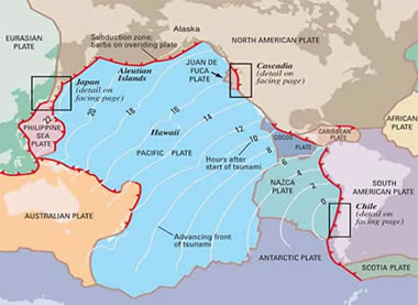
Tsunamis can be created by the rapid displacement of water when the sea floor lifts and/or falls due to crustal movements that accompany very large earthquakes. The shallow nature of the sea floor off the coast of Alaska could increase the destructive potential of a tsunami wave in the Pacific.
"Peat layers provide a clear picture of what's happened to the Earth. Our data indicate that two major earthquakes have struck Alaska in the last 1,500 years and our findings show that a bigger earthquake and a more destructive tsunami than the 1964 event are possible in the future. The region has been hit by large single event earthquakes and tsunamis before, and our evidence indicates that multiple and more extensive ruptures can happen."
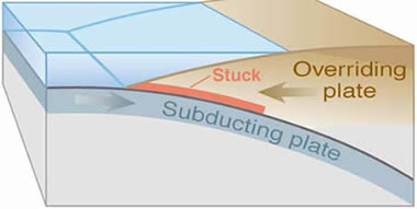
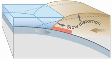
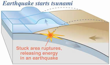
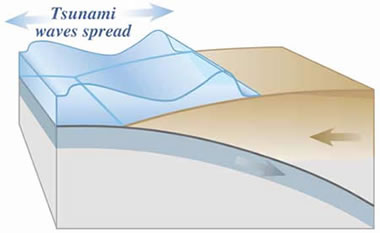
Causes of a Tsunami
Tsunamis can be created by the rapid displacement of water when the sea floor lifts and/or falls due to crustal movements that accompany very large earthquakes. The shallow nature of the sea floor off the coast of Alaska could increase the destructive potential of a tsunami wave in the Pacific.
Prof Ron Bruhn from the University of Utah said: "If the larger earthquake that is suggested by our work hits the region, the size of the potential tsunami could be signficantly larger than in 1964 because a multi-rupture quake would displace the shallow continental shelf of the Yakutat microplate."
"In the case of a multi-rupture event, the energy imparted to the tsunami will be larger but spread out over a longer strike distance. Except for the small communities at the tsunami source in Alaska, the longer length will have more of an effect on areas farther from the source such as southeastern Alaska, British Columbia, and the US west coast from Washington to California."
Tsunami Warning Systems
Warning systems have been in place on the US western seaboard and Hawaii since the 1946 Aleutian Islands tsunami. Improvements were made following the 2004 earthquake under the Indian Ocean that triggered the most deadly tsunami in recorded history, killing more than 230,000 people.
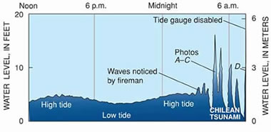
Prof Shennan said: "Earthquakes can hit at any time of the day or night, and that's a big challenge for emergency planners. A tsunami in this region could cause damage and threaten life from Alaska to California and beyond; in 1964 the effects of the tsunami waves were felt as far away as southern California and were recorded on tide gages throughout the Pacific Ocean."
Dr George Plafker from Plafker Geohazard Consultants said: "A large scale earthquake will not necessarily create a large wave. Tsunami height is a function of bathymetry, and the amount of slip and dip of the faults that take up the displacement, and all these factors can vary greatly along the strike."
"Tsunamis will occur in the future. There are issues in warning and evacuating large numbers of people in coastal communities quickly and safely. The US has excellent warning systems in place but awareness is vital."